Joe Medina produced this video clip. I met Joe in the world of politics and so happens that we both are immigrants except he was born in Colombian while I was born in Bolivia. We also have different skills, he is a film producer and I am an engineering. Except for the man talking in the clip Joe did a superb job.
Showing posts with label Houston. Show all posts
Showing posts with label Houston. Show all posts
Friday, May 8, 2009
Wednesday, April 29, 2009
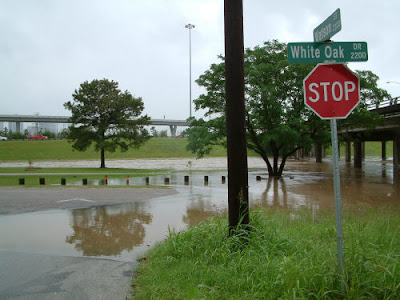
April 28, 2009 Houston: White Oak Bayou
Another day in Houston after a rainy night. Soils saturated and some added water to an ever flood prone area. An early morning walk to Stude Park a couple blocks from home. The corner of White Oak and Watson almost under water...
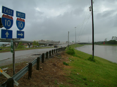
 Over the bridge and looking west. I-10 on the left and White Oak Bayou on the right forming lake front property...
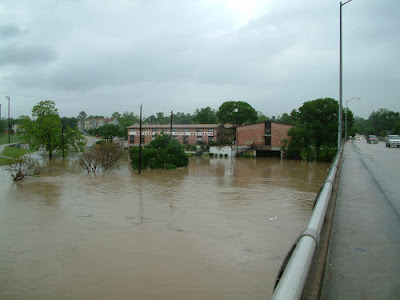
 Ricardo on his way to work telling me of the floods in 1990 when he saw three vehicles floating down stream along White Oak Bayou. Ricardo is originally a farmer from Mexico and migrant worker. He is a US resident since late 80's. Not a citizen yet but five members of his family are citizens and they vote. Meeting candidate Camacho gave him an added incentive to become a US citizen...
 Area favorite apartments under usual water levels. Somebody forgot to move their cars overnight...
 Channel 11 and Univision filming footage and waiting for water levels to increase. Note there vehicles halfway under the water...
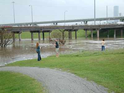
 Residents from the First Ward enjoying photo ops ...
 Another vehicle under water on White Oak Drive...
 Mango Beach in the Heights. Univision getting ready to interview Simel the businessman behind Mango Beach...
 Met Simel through Joe Yayo "el rolo brusco" Medina from Colombia. Simel is attending the police academy with hopes to become a police officer with Harris County and he enjoys running his Mango Beach coffee and refreshment shop...
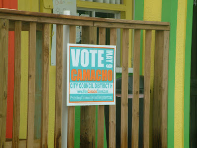
 Of course, it is campaign season and vote for Camacho sign blends in with the Mango Beach colors...
 Over the bridge and looking west. I-10 on the left and White Oak Bayou on the right forming lake front property...
 Ricardo on his way to work telling me of the floods in 1990 when he saw three vehicles floating down stream along White Oak Bayou. Ricardo is originally a farmer from Mexico and migrant worker. He is a US resident since late 80's. Not a citizen yet but five members of his family are citizens and they vote. Meeting candidate Camacho gave him an added incentive to become a US citizen...
 Area favorite apartments under usual water levels. Somebody forgot to move their cars overnight...
 Channel 11 and Univision filming footage and waiting for water levels to increase. Note there vehicles halfway under the water...
 Residents from the First Ward enjoying photo ops ...
 Another vehicle under water on White Oak Drive...
 Mango Beach in the Heights. Univision getting ready to interview Simel the businessman behind Mango Beach...
 Met Simel through Joe Yayo "el rolo brusco" Medina from Colombia. Simel is attending the police academy with hopes to become a police officer with Harris County and he enjoys running his Mango Beach coffee and refreshment shop...
 Of course, it is campaign season and vote for Camacho sign blends in with the Mango Beach colors...
Saturday, April 18, 2009
Hurricane Preparedness: Evacuation vs. "Hunker Down"
When I proposed the alternative to tunnel I-45 (www.i45parkway.com) it was brought to my attention that I-45 could not be tunneled (among other opinions) because it was an emergency evacuation route. The Harris County Homeland Security & Emergency Management office has it shown on its web site along with evacuation zones. The same page also has a link to the I-45 Contraflow Routes and contraflow routes for I-10, US-290 and US-59.
As a registered professional engineering in the state of Texas my primary duty in the practice of my profession is public safety thus I invested hundreds if not thousands of hours considering emergency evacuation, in particular hurricane evacuation. The result was that tunneling of I-45 is a must. Here is why:
As a humble servant to the safety of the public, my understanding of hurricane preparedness plan in the Houston region consists of the following:
Below few links to remind what Katrina, Rita and Ike caused:
Collecting and Preserving the Stories of Katrina and Rita
Hurricane Katrina Editorial & Stock Image Archives
The Short But Eventful Life of Ike
As a registered professional engineering in the state of Texas my primary duty in the practice of my profession is public safety thus I invested hundreds if not thousands of hours considering emergency evacuation, in particular hurricane evacuation. The result was that tunneling of I-45 is a must. Here is why:
- Current conditions of I-45 (downtown to Beltway 8) are sub standard, unsafe and lack capacity.
- Federal process for development of highways takes 10 years which Houston cannot afford to wait.
- Standard reconstruction of highways require traffic control that reduces traffic capacity. Reduced traffic capacity during an emergency evacuation route is likely not a good option.
- Standard reconstruction of highways takes many years, i.e. I-10 took 8 years considering it had an additional 100-foot of right of way for expansion. I-45 does not have additional right of way.
- I-45 north of downtown Houston floods during normal rain conditions, so does I-10.
- Construction is done below ground with little interference with existing traffic.
- Allows connecting all major routes from US-59 south of downtown to Beltway 8 at Greenspoint.
- Addresses the challenge to adding capacity to the Pierce Elevated.
- Construction is less than five years.
- Estimated cost for the proposed I-45 tunnels is about 5% more when considering construction time.
- The I-45 (twin) tunnel proposal is designed for emergency evacuation and contraflow.
- Highway tunnels are and can be designed as emergency shelters.
- Highway tunnels can be constructed in Houston's soil conditions and are designed NOT to flood.
- The approved preferred alternative intends to reconstruct the existing I-45 and add one or three more lanes, from the existing (8 main lanes, 1 HOV lane, 4 service road lanes) to the proposed (8 main lanes, 2 or 4 HOV lanes, and 4 service road lanes). By Texas law only new lanes can be tolled, thus only the proposed HOV lanes could be tolled.
- The proposed twin tunnel I-45 Tunnel/Parkway would add a total of 12 more new lanes to the I-45 corridor from south of downtown Houston to Beltway 8 at Greenspoint, most of it in District H.
- TxDOT's preferred alternative by increasing the number of lanes: increases width of pavement, does not prevent noise nor air pollution, does not provide significant added capacity to the corridor, allows toll revenue only on HOV lanes, increases the demand for floodwater detention, and may require right of way taking.
- The alternative I-45 tunnels add 12 lanes: allows reconstruction of I-45 without the need for expansion, reduces or eliminates noise and air pollution, more than doubles the I-45 corridor capacity, it is a toll only facility, does not require flood mitigation, does not require additional right of way, and improves regional traffic flow.
- Doubles the corridor capacity
- Provides traffic flow management through user fees
- It is a world class engineering project, one of a kind
- Provides a 100-year vision for the corridor
- Allows development of the I-45 parkway with multi modal transportation uses (i.e. light rail)
As a humble servant to the safety of the public, my understanding of hurricane preparedness plan in the Houston region consists of the following:
- Evacuation zones identified as potential flood zones based on expected levels of surge caused by hurricane winds. These zones can be found in the Evacuation Map provided by Harris County.
- The Houston region has identified roadways as emergency evacuation routes. I-45 is one of the principal routes for evacuating the Glaveston area and the 610 and Beltway 8 loops are used as traffic feeders/cconnectors to US-59, I-45, US-290, and I-10.
- Outside the evacuation zones residents are expected to "hunker down" and ride out the storm/hurricane.
- Coastal Community - Appears to be a federal designation of coastal areas expected to be evacuated in case of an emergency such as a hurricane.
- Hurricane preparedness plan - Houston's plan appears to be based on potential for flooding but appears not to address wind forces.
- Hunker down - The order given to the Houston region not included in the flood zones. It is equated to stay at home to ride out the storm/hurricane winds.
- First responders - Who are the first responders and how are they and their vehicles protected from potential hurricane impacts?
- Risk of flooding - Houston is prone to flooding. It appears that the potential for highway flooding, such as I-45 and I-10 north of downtown, is perceived to be small. How small? What is the likely that highways such as I-45 and I-10 be flooded for a short period of time prior or during evacuation orders? What is this probability over the next 10 years since it will take 10 years or more for I-45 and/or I-10 to be reconstructed?
- Hurricane shelters - How many people and for how long will hurricane shelters be needed?
- At-risk populations - Children, the elderly and low income families are generally the most affected by emergency situations like hurricane evacuations. How are they prepared?
- Build the I-45 tunnels from US-59/288 south of downtown Houston to Beltway 8 at Greenspoint - Two objectives for this: one, to provide a better emergency evacuation route and two, to provide emergency shelter for at-risk population and emergency vehicles.
- Develop a pilot program that builds future schools for dual purpose, improve education and provide emergency shelter - The proposed pilot program is to design a multi purpose education center that includes one or more of the following : school, community center, library, after school program, and play grounds or park spaces. These multi purpose education center is to be designed and constructed to withstand category 5 hurricanes and be sustainable to house communities over long periods of time. These could incorporate solar power energy which can be sold back to the grid and/or implement multi purpose green areas that could be used for recreation and flood management.
- Implement a free program to rate all structures for hurricane categories - Partner with organizations such as the AIA to rate structure that could be used for hurricane protection in terms of category categories. New construction should also be rated for hurricane categories and home buyers be given the option to upgrade structures to higher hurricane standards.
Below few links to remind what Katrina, Rita and Ike caused:
Collecting and Preserving the Stories of Katrina and Rita
Hurricane Katrina Editorial & Stock Image Archives
The Short But Eventful Life of Ike
Subscribe to:
Posts (Atom)
