What is it the Alaska Viaduct?
Paid for by Not Another Elevated Viaduct...
Say NO to another viaduct and YES to waterfront
The early view of what is to come, bored tunnel...
The latest SR99 Bored Tunnel Video
and what the future holds, an accessible waterfront without a highway/viaduct...
Monday, August 10, 2009
Thursday, May 14, 2009
May 14, 2009 Seattle, Washington Signs Their Tunnel Into Law
News from Seattle, Washington where legislators have signed into law the building of the tunnel. The quote below the photo is unique and had got to include who the "techy tunnel dudes" were. Also note the person signing the email was Bob Donegan.
 Hi techy tunnel dudes!
I thought you might enjoy this description of yesterday’s signing ceremony, written by my hero Bob Donegan, leader of the SR99 coalition. Big thanks to you for signing tunnel expert letters as well as checks to the SR99 Coalition. This could not have happened without the benefit of your technical credibility and support!
Following are the techy tunnel dudes to who the email was sent to. Note the name of the companies:
Kern Jacobson (MacCap Advisors) Macquarie Group, Mit K. Jha David Evans and Associates, Vladimir Khazak HNTB, Richard Prust ARUP, Dr. Gerhard Sauer Dr. Sauer Group, Juergen Laubbichler Dr. Sauer Group, Nicholas Taylor ARUP, Page, Dick HNTB, Bob Donegan Ivar's Seafood
A pdf of what the SR 99 Coalition is after at pdf.
And and expert from the news release:
Speaking of work, the three stakeholder committees (north, south portals and central waterfront) have begun meeting, and we will continue to work to make sure:
Wildly expanded Transit is part of the solution
The seawall is replaced
The north portal works for S Lake Union, Queen Anne, Interbay, Magnolia, Ballard, and points NW
A terrific waterfront is developed, including easier access to and from Elliott and Western access
Costs stay within plan
South Portal works, esp for Stadiums and Pioneer Square and the Port
Work is done, when possible, off season to minimize disruption
The elected in the city, port, and county know of our concerns as they work to find funds to support their commitments
The project teams continue to keep all informed and listen to contrary viewpoints
As Always,
Mistakes herein are mine alone, but,
I remain,
Bob
Friday, May 8, 2009
May 1, 2009 Early Vote Email Part I
The following email was sent to area residents and civic minded individuals active in District H.
May 1, 2009
Dear Friend,
As you know I am a candidate for District H (see attached District H map). Since 2000 I live in the Woodland Heights in a house built in 1920 that is close to White Oak Bayou. I not only see my house appraisal value and tax increase every year but also the potential for flooding.
Our education system is terrible with over 50% failure rate and it needs fixing. Our failure in education fuels crime rates which in the past year have increase to levels I have never seen in the neighborhoods.
These and others are areas that are of concern and need fixing but the main reason why I am running for city council is because when proposing the tunneling of I45 (www.i45parkway.com which is similar to a project in Spain www.mc30.es) I learned that our hurricane preparedness plan is designed to fail. But it can be improved by:
1. Building the i45 tunnel, which will improve hurricane evacuation and provide emergency shelter (also fuel the local economy).
2. Build dual-purpose schools that are designed for education as well as for emergency shelter.
3. Rate homes and structures for hurricane categories so we don’t have to guess whether our homes will survive hurricane winds else can find shelter elsewhere.
Since 2004 many of you have seen me working as a volunteer advocating the construction of the i45 tunnel. TxDOT told us that TxDOT could build the i45 tunnel if city council supports it but so far city council has not. You have one last opportunity to make this project a reality, vote for me so I can continue pushing for this project. Please read my latest email to TxDOT and Harris County (attached).
I have been a volunteer with civic organizations in District H since 1995 so I know the District. Although we are having elections this May 9th that is for a six-month period of time since re-elections will be held again in November. If elected this May, the following items are the minimum tasks I plan to accomplish by November of 2009:
1. Establish super neighborhoods as the foundation to representing and governing District H.
2. Implement a referendum for November 09 elections calling to freeze property values for historically registered homes and structures.
3. Implement a park/green-area neighborhood program to mitigate flooding.
4. Implement crime prevention though environmental design, neighborhood surveillance using cameras, and get police to patrol neighborhoods vs. highways.
5. Use my civil engineering skills to address concerns regarding the CIP, lack of funding and establish priorities for infrastructure needs.
With your help these five items can be accomplished by November 2009 but first you have to help me get out the vote by contacting others and vote for CAMACHO for District H.
Only about 4000 people will vote so you can have a significant impact in this election.
Thank you for your support.
g. camacho
www.votecamachotunnel.com
www.votecamachotunnel.blogspot.com (new)
"For things to change we have to change, for things to get better we have to get better."
The i - 45 Expansion Camacho Tunnel Alternative
Joe Medina produced this video clip. I met Joe in the world of politics and so happens that we both are immigrants except he was born in Colombian while I was born in Bolivia. We also have different skills, he is a film producer and I am an engineering. Except for the man talking in the clip Joe did a superb job.
Monday, May 4, 2009
May 4, 2009 Houston District H Election - Early vote
City of Houston is divided in 9 districts. District H has about 90 thousand registered voters. If not possible to vote on election day people may request to mail in their vote. Then they have from April 27th to May 5th to early vote and last is May 9th, election day. With a little luck maybe mail in votes and early votes will reach a total of 2000 votes. The following photos are unrelated to voting, just some pictures taken during the week...
 A gentleman walking in the afternoon. He used to drive a truck but had an event and cannot drive trucks any longer. He said he lost his legs.
 A lovely kid back home from a long day at school or whatever else kids do during the day.
 Prelude to the Bach Society choir at Christ the King Lutheran Church in midtown.
 Hugo Mojica one of the candidates for District H.
 Working at the polls handing out fliers to voters
 The Mojica family working the polls.
 Wars of the signs.
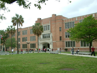 For those of you who know this building.
 Robert volunteering to work at Moody Park. He wants to be a photographer.
 Oops, I did take your picture.
 More candidate supporters working early voters.
 And how did Lupe get in the mix? Looking forwards to Tuesday morning coffee & visit. Do you think Mojica will be up early enough to join us? :)
 Mrs. Dorsey and her mother. So great to get to know Mrs. Dorsey and receive her guidance.
 Over achiever. Would be superb if us adults would take on the world as this 2 year old takes on the basket.
 Parents at Travis Elementary waiting for the parade to arrive.
 Drumming of the colors.
 Ladies hanging in the back of a 1950's car (my guess on the decade).
 I hear Houston Fire Department is under funded. I wonder if they leased their truck for the parade.
 Great. Put the children to walk while the adults ride the limo.
 At the tail end of the parade.
 A trio of friends at Travis Elementary after the parade.
 Any child could be very happy with some ice cream. That is to show no need to have ice cream to be happy, see the one behind :)
 Father and daughter at Travis.
 Great kids.
 Barbara Bush was the invited speaker to the 100 year celebration of Travis Elementary.
 Fred and his daughter.
Wednesday, April 29, 2009
April 28, 2009 Houston: White Oak Bayou
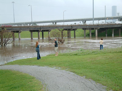
Another day in Houston after a rainy night. Soils saturated and some added water to an ever flood prone area. An early morning walk to Stude Park a couple blocks from home. The corner of White Oak and Watson almost under water...
 Over the bridge and looking west. I-10 on the left and White Oak Bayou on the right forming lake front property...
 Ricardo on his way to work telling me of the floods in 1990 when he saw three vehicles floating down stream along White Oak Bayou. Ricardo is originally a farmer from Mexico and migrant worker. He is a US resident since late 80's. Not a citizen yet but five members of his family are citizens and they vote. Meeting candidate Camacho gave him an added incentive to become a US citizen...
 Area favorite apartments under usual water levels. Somebody forgot to move their cars overnight...
 Channel 11 and Univision filming footage and waiting for water levels to increase. Note there vehicles halfway under the water...
 Residents from the First Ward enjoying photo ops ...
 Another vehicle under water on White Oak Drive...
 Mango Beach in the Heights. Univision getting ready to interview Simel the businessman behind Mango Beach...
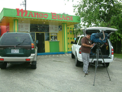 Met Simel through Joe Yayo "el rolo brusco" Medina from Colombia. Simel is attending the police academy with hopes to become a police officer with Harris County and he enjoys running his Mango Beach coffee and refreshment shop...
 Of course, it is campaign season and vote for Camacho sign blends in with the Mango Beach colors...
Saturday, April 18, 2009
Hurricane Preparedness: Evacuation vs. "Hunker Down"
When I proposed the alternative to tunnel I-45 (www.i45parkway.com) it was brought to my attention that I-45 could not be tunneled (among other opinions) because it was an emergency evacuation route. The Harris County Homeland Security & Emergency Management office has it shown on its web site along with evacuation zones. The same page also has a link to the I-45 Contraflow Routes and contraflow routes for I-10, US-290 and US-59.
As a registered professional engineering in the state of Texas my primary duty in the practice of my profession is public safety thus I invested hundreds if not thousands of hours considering emergency evacuation, in particular hurricane evacuation. The result was that tunneling of I-45 is a must. Here is why:
As a humble servant to the safety of the public, my understanding of hurricane preparedness plan in the Houston region consists of the following:
Below few links to remind what Katrina, Rita and Ike caused:
Collecting and Preserving the Stories of Katrina and Rita
Hurricane Katrina Editorial & Stock Image Archives
The Short But Eventful Life of Ike
As a registered professional engineering in the state of Texas my primary duty in the practice of my profession is public safety thus I invested hundreds if not thousands of hours considering emergency evacuation, in particular hurricane evacuation. The result was that tunneling of I-45 is a must. Here is why:
- Current conditions of I-45 (downtown to Beltway 8) are sub standard, unsafe and lack capacity.
- Federal process for development of highways takes 10 years which Houston cannot afford to wait.
- Standard reconstruction of highways require traffic control that reduces traffic capacity. Reduced traffic capacity during an emergency evacuation route is likely not a good option.
- Standard reconstruction of highways takes many years, i.e. I-10 took 8 years considering it had an additional 100-foot of right of way for expansion. I-45 does not have additional right of way.
- I-45 north of downtown Houston floods during normal rain conditions, so does I-10.
- Construction is done below ground with little interference with existing traffic.
- Allows connecting all major routes from US-59 south of downtown to Beltway 8 at Greenspoint.
- Addresses the challenge to adding capacity to the Pierce Elevated.
- Construction is less than five years.
- Estimated cost for the proposed I-45 tunnels is about 5% more when considering construction time.
- The I-45 (twin) tunnel proposal is designed for emergency evacuation and contraflow.
- Highway tunnels are and can be designed as emergency shelters.
- Highway tunnels can be constructed in Houston's soil conditions and are designed NOT to flood.
- The approved preferred alternative intends to reconstruct the existing I-45 and add one or three more lanes, from the existing (8 main lanes, 1 HOV lane, 4 service road lanes) to the proposed (8 main lanes, 2 or 4 HOV lanes, and 4 service road lanes). By Texas law only new lanes can be tolled, thus only the proposed HOV lanes could be tolled.
- The proposed twin tunnel I-45 Tunnel/Parkway would add a total of 12 more new lanes to the I-45 corridor from south of downtown Houston to Beltway 8 at Greenspoint, most of it in District H.
- TxDOT's preferred alternative by increasing the number of lanes: increases width of pavement, does not prevent noise nor air pollution, does not provide significant added capacity to the corridor, allows toll revenue only on HOV lanes, increases the demand for floodwater detention, and may require right of way taking.
- The alternative I-45 tunnels add 12 lanes: allows reconstruction of I-45 without the need for expansion, reduces or eliminates noise and air pollution, more than doubles the I-45 corridor capacity, it is a toll only facility, does not require flood mitigation, does not require additional right of way, and improves regional traffic flow.
- Doubles the corridor capacity
- Provides traffic flow management through user fees
- It is a world class engineering project, one of a kind
- Provides a 100-year vision for the corridor
- Allows development of the I-45 parkway with multi modal transportation uses (i.e. light rail)
As a humble servant to the safety of the public, my understanding of hurricane preparedness plan in the Houston region consists of the following:
- Evacuation zones identified as potential flood zones based on expected levels of surge caused by hurricane winds. These zones can be found in the Evacuation Map provided by Harris County.
- The Houston region has identified roadways as emergency evacuation routes. I-45 is one of the principal routes for evacuating the Glaveston area and the 610 and Beltway 8 loops are used as traffic feeders/cconnectors to US-59, I-45, US-290, and I-10.
- Outside the evacuation zones residents are expected to "hunker down" and ride out the storm/hurricane.
- Coastal Community - Appears to be a federal designation of coastal areas expected to be evacuated in case of an emergency such as a hurricane.
- Hurricane preparedness plan - Houston's plan appears to be based on potential for flooding but appears not to address wind forces.
- Hunker down - The order given to the Houston region not included in the flood zones. It is equated to stay at home to ride out the storm/hurricane winds.
- First responders - Who are the first responders and how are they and their vehicles protected from potential hurricane impacts?
- Risk of flooding - Houston is prone to flooding. It appears that the potential for highway flooding, such as I-45 and I-10 north of downtown, is perceived to be small. How small? What is the likely that highways such as I-45 and I-10 be flooded for a short period of time prior or during evacuation orders? What is this probability over the next 10 years since it will take 10 years or more for I-45 and/or I-10 to be reconstructed?
- Hurricane shelters - How many people and for how long will hurricane shelters be needed?
- At-risk populations - Children, the elderly and low income families are generally the most affected by emergency situations like hurricane evacuations. How are they prepared?
- Build the I-45 tunnels from US-59/288 south of downtown Houston to Beltway 8 at Greenspoint - Two objectives for this: one, to provide a better emergency evacuation route and two, to provide emergency shelter for at-risk population and emergency vehicles.
- Develop a pilot program that builds future schools for dual purpose, improve education and provide emergency shelter - The proposed pilot program is to design a multi purpose education center that includes one or more of the following : school, community center, library, after school program, and play grounds or park spaces. These multi purpose education center is to be designed and constructed to withstand category 5 hurricanes and be sustainable to house communities over long periods of time. These could incorporate solar power energy which can be sold back to the grid and/or implement multi purpose green areas that could be used for recreation and flood management.
- Implement a free program to rate all structures for hurricane categories - Partner with organizations such as the AIA to rate structure that could be used for hurricane protection in terms of category categories. New construction should also be rated for hurricane categories and home buyers be given the option to upgrade structures to higher hurricane standards.
Below few links to remind what Katrina, Rita and Ike caused:
Collecting and Preserving the Stories of Katrina and Rita
Hurricane Katrina Editorial & Stock Image Archives
The Short But Eventful Life of Ike
Subscribe to:
Posts (Atom)
